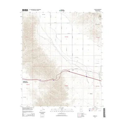
2014 Map of Ligurta
USGS Topo · Published 2014About this map
Ligurta and Wellton anchor the transition between desert basin and mountain pass in this Southwest landscape. The Gila River winds through the northern reaches, supporting agriculture in Dome Valley and necessitating infrastructure like N Gila Levee Rd and S Gila Levee Rd. To the west, the steep rise of the Gila Mountains is pierced by Telegraph Pass, a critical corridor for modern transportation and historical movement. To the northeast, the Muggins Mountains dominate the horizon, featuring Muggins Peak and Long Mtn. This geography illustrates the vital connection between water and travel in the arid Yuma Desert, where the Old US-80 alignment and newer interstate routes parallel the ancient river course. The map details the grid-like expansion of Fortuna Foothills as it encroaches upon the alluvial fans and desert washes like Twin Tanks Wash.
Find a feature on this map
34 named features on this map. Tap any name to fly to it.
Don’t see what you’re looking for? This feature index may not catch every label — zoom into the map to look around manually.
Map Details
Editions of this 2014 Ligurta Map
This is the sole edition of this map. No revisions or reprints were ever made.
Other maps of this area

1926 · Fortuna
USGS Topo · 1:62,500

1926 · Wellton
USGS Topo · 1:62,500

1929 · Fortuna
USGS Topo · 1:62,500

1929 · Laguna
USGS Topo · 1:62,500

1929 · Wellton
USGS Topo · 1:62,500

1942 · Yuma
USGS Topo · 1:250,000

1943 · Laguna
USGS Topo · 1:62,500

1954 · El Centro
USGS Topo · 1:250,000

1955 · El Centro
USGS Topo · 1:250,000
1955 · Dome
USGS Topo · 1:24,000