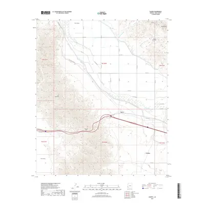
2018 Map of Ligurta
USGS Topo · Published 2018About this map
The Gila River winds through the northern portion of this map, nourishing the agricultural expanse of Dome Valley before cutting between distinct mountain ranges. To the north, the Muggins Mountains rise toward Muggins Peak, while the Gila Mountains dominate the western landscape. This region serves as a vital corridor for transportation, where the modern interstate and Old Hwy 80 parallel the historic route of the E Butterfield Stage Rd.
Find a feature on this map
39 named features on this map. Tap any name to fly to it.
Don’t see what you’re looking for? This feature index may not catch every label — zoom into the map to look around manually.
Map Details
Editions of this 2018 Ligurta Map
This is the sole edition of this map. No revisions or reprints were ever made.
Other maps of this area

1926 · Fortuna
USGS Topo · 1:62,500

1926 · Wellton
USGS Topo · 1:62,500

1929 · Fortuna
USGS Topo · 1:62,500

1929 · Laguna
USGS Topo · 1:62,500

1929 · Wellton
USGS Topo · 1:62,500

1942 · Yuma
USGS Topo · 1:250,000

1943 · Laguna
USGS Topo · 1:62,500

1954 · El Centro
USGS Topo · 1:250,000

1955 · El Centro
USGS Topo · 1:250,000
1955 · Dome
USGS Topo · 1:24,000