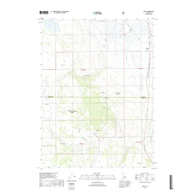
2018 Map of Likely
USGS Topo · Published 2018About this map
Likely stands as the primary settlement on this northeastern California landscape, situated near the South Fork Pit River and the Likely Cem. The area is defined by the transition from the irrigated valley floor, featuring the W Side Canal and Delta Lake, to the high timber and volcanic peaks of the Modoc National Forest. Transportation history is visible through the Modoc Line Rail Trail, which traces a former rail corridor north-south through the terrain. To the south, the topography rises sharply toward Likely Mtn, where the Likely Mtn Lookout oversees a rugged expanse of canyons including Stones Canyon and Montgomery Canyon. This 2018 survey captures the region's ranching and forestry character, preserved in named landmarks like Smokey Charley Spring, Johnny Ois Spring, and Harter Flat.
Find a feature on this map
42 named features on this map. Tap any name to fly to it.
Don’t see what you’re looking for? This feature index may not catch every label — zoom into the map to look around manually.
Map Details
Editions of this 2018 Likely Map
This is the sole edition of this map. No revisions or reprints were ever made.
Other maps of this area

1886 · Alturas
USGS Topo · 1:250,000

1892 · Alturas
USGS Topo · 1:250,000

1954 · Alturas
USGS Topo · 1:250,000

1958 · Alturas
USGS Topo · 1:250,000

1961 · Alturas
USGS Topo · 1:62,500

1962 · Alturas
USGS Topo · 1:250,000

1962 · Tule Mountain
USGS Topo · 1:24,000
1962 · Madeline
USGS Topo · 1:24,000

1962 · Likely
USGS Topo · 1:62,500

1963 · Little Juniper Reservoir
USGS Topo · 1:24,000