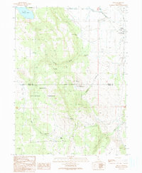
1990 Map of Likely
USGS Topo · Published 1990About this map
Likely sits at the eastern edge of this landscape where high desert terrain meets the irrigated agricultural systems of the Eastside Canal. The map reveals a transition from the rugged slopes of the Modoc National Forest, featuring prominent peaks like Likely Mountain and Bald Mountain, to the managed water infrastructure of the valley floor. Evidence of local community life is centered around the South Fork Union Sch, a local Cem, and a Landing Strip situated near the South Fork river. To the north, the presence of Alkali Lake and Delta Lake indicates the terminal drainage patterns of this high-altitude basin. The boundary between Modoc and Lassen counties cuts horizontally across the central mountains, passing through Stones Canyon and near Little Bald Mountain. A network of water sources, from Smokey Charley Spring to Dogg Spring, highlights the critical importance of spring water for livestock in this rangeland, supported by scattered structures like the Corral and Fire Station.
Find a feature on this map
39 named features on this map. Tap any name to fly to it.
Don’t see what you’re looking for? This feature index may not catch every label — zoom into the map to look around manually.
Map Details
Editions of this 1990 Likely Map
This is the sole edition of this map. No revisions or reprints were ever made.
Other maps of this area

1886 · Alturas
USGS Topo · 1:250,000

1892 · Alturas
USGS Topo · 1:250,000

1954 · Alturas
USGS Topo · 1:250,000

1958 · Alturas
USGS Topo · 1:250,000

1961 · Alturas
USGS Topo · 1:62,500

1962 · Alturas
USGS Topo · 1:250,000

1962 · Tule Mountain
USGS Topo · 1:24,000
1962 · Madeline
USGS Topo · 1:24,000

1962 · Likely
USGS Topo · 1:62,500

1963 · Little Juniper Reservoir
USGS Topo · 1:24,000