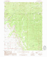
1985 Map of Lila Point
USGS Topo · Published 1985About this map
The Book Cliffs dominate this portion of the East Coal Field, where steep escarpments and deep drainages define the transition between high plateaus and the desert below. This mid-1980s provisional study documents the intricate hydrological network of the area, including Little Park Wash and Marsh Flat Wash. The rugged geography is anchored by Lila Point and The Cove, while several prominent canyons such as Horse Canyon, Bear Canyon, and Nelson Canyon cut through the uplifted strata. The boundary between Carbon Co and Emery Co runs through the northern portion of the map, highlighting a region historically vital for mining and resource extraction. Significant natural landmarks like Buckskin and Williams Draw provide essential points of reference in a landscape characterized by its dramatic vertical relief and seasonal watercourses.
Find a feature on this map
21 named features on this map. Tap any name to fly to it.
Don’t see what you’re looking for? This feature index may not catch every label — zoom into the map to look around manually.
Map Details
Editions of this 1985 Lila Point Map
This is the sole edition of this map. No revisions or reprints were ever made.
Other maps of this area

1886 · Price River
USGS Topo · 1:250,000

1896 · Price River
USGS Topo · 1:250,000

1915 · Sunnyside
USGS Topo · 1:62,500

1948 · Woodside
USGS Topo · 1:62,500

1949 · Woodside
USGS Topo · 1:62,500

1950 · Woodside
USGS Topo · 1:62,500

1954 · Flat Canyon
USGS Topo · 1:62,500

1954 · Range Creek
USGS Topo · 1:62,500

1956 · Price
USGS Topo · 1:250,000

1960 · Price
USGS Topo · 1:250,000