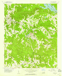
1956 Map of Lilesville
USGS Topo · Published 1957About this map
Lilesville serves as the primary hub in this mid-1950s landscape, positioned along the busy Seaboard Air Line corridor. The geography is characterized by the significant water resources of the Pee Dee River and Blewett Falls Lake, where a prominent Powerhouse and Spillway manage the river's flow near Big Island. Away from the water, the topography is heavily marked by industrial activity, particularly the extensive Strip Mine and other Mine operations located near Gum Springs Ch.
Find a feature on this map
39 named features on this map. Tap any name to fly to it.
Don’t see what you’re looking for? This feature index may not catch every label — zoom into the map to look around manually.
Map Details
Editions of this 1956 Lilesville Map
3 editions found
Other maps of this area

1941 · Spartanburg
USGS Topo · 1:250,000

1942 · Troy
USGS Topo · 1:125,000

1942 · Rockingham
USGS Topo · 1:125,000

1953 · Florence
USGS Topo · 1:250,000

1953 · Raleigh
USGS Topo · 1:250,000

1953 · Spartanburg
USGS Topo · 1:250,000

1953 · Charlotte
USGS Topo · 1:250,000

1954 · Charlotte
USGS Topo · 1:250,000

1954 · Florence
USGS Topo · 1:250,000

1954 · Raleigh
USGS Topo · 1:250,000