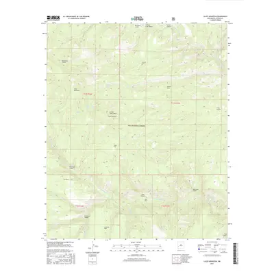
2017 Map of Lilley Mountain
USGS Topo · Published 2017About this map
Papineau Grave marks a solitary point of human history in this remote section of the Gila National Forest, where the complex drainage systems of the Middle Fork Gila River and West Fork Gila River meet. The terrain is defined by dramatic elevation changes across the Jerky Mountains and high plateaus like Jackson Mesa and Cub Mesa. This 2017 survey details the critical water sources that sustained early activity in the high country, including Lower Marrs Spring, Quentin Spring, and Lilley Park Spring. Significant landmarks such as Lilley Mountain and Lilley Park anchor the central portion of the map, while named canyons like Moonshine Canyon, Hells Hole Canyon, and Packsaddle Canyon illustrate the deep erosion patterns of the Mogollon Plateau.
Find a feature on this map
35 named features on this map. Tap any name to fly to it.
Don’t see what you’re looking for? This feature index may not catch every label — zoom into the map to look around manually.
Map Details
Editions of this 2017 Lilley Mountain Map
This is the sole edition of this map. No revisions or reprints were ever made.
Other maps of this area

1910 · Mogollon
USGS Topo · 1:125,000

1911 · Alum Mountain
USGS Topo · 1:125,000

1912 · Mogollon
USGS Topo · 1:125,000

1913 · Alum Mountain
USGS Topo · 1:125,000

1954 · Clifton
USGS Topo · 1:250,000

1957 · Clifton
USGS Topo · 1:250,000

1958 · Clifton
USGS Topo · 1:250,000

1962 · Clifton
USGS Topo · 1:250,000

1963 · Negrito Mountain
USGS Topo · 1:24,000
1963 · Loco Mountain
USGS Topo · 1:24,000