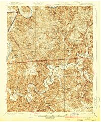
1929 Map of Lillydale
USGS Topo · Published 1942About this map
The Cumberland River and Obey River dictate the settlement patterns of this borderland region between Tennessee and Kentucky in the 1920s. Long before the creation of modern reservoirs, this landscape was defined by deep river bends and fertile bottoms such as Washes Bottom and Willis Bottom. The map reveals a dense network of upland communities sustained by small stores and one-room schools, including Gaings Hill School and the Jennings Store School.
Find a feature on this map
113 named features on this map. Tap any name to fly to it.
Don’t see what you’re looking for? This feature index may not catch every label — zoom into the map to look around manually.
Map Details
Editions of this 1929 Lillydale Map
3 editions found
Other maps of this area

1897 · Standingstone
USGS Topo · 1:125,000

1898 · Standingstone
USGS Topo · 1:125,000

1924 · Lillydale
USGS Topo · 1:62,500

1925 · Gainesboro
USGS Topo · 1:62,500

1926 · Lillydale
USGS Topo · 1:62,500

1929 · Lillydale
USGS Topo · 1:62,500

1929 · Byrdstown
USGS Topo · 1:62,500

1929 · Gainesboro
USGS Topo · 1:62,500

1929 · Tompkinsville
USGS Topo · 1:62,500

1944 · Livingston
USGS Topo · 1:24,000