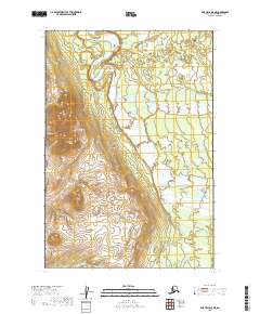
2019 Map of Lime Hills D-5 NE
USGS Topo · Published 2019About this map
Big River dominates the central corridor of this interior landscape, winding through a glacial valley between high, unnamed peaks. The river’s braided channels and wide gravel bars suggest a dynamic hydrological environment where the watercourse shifts seasonally across the valley floor. To the east, the North Fork Big River joins the main stem, creating a complex network of wetlands and smaller tributaries that drain the surrounding alpine slopes. The lack of named settlements or man-made infrastructure emphasizes the wilderness character of the Bethel Census Area during this period, with the topography defined primarily by the steep contours of the surrounding mountains and the persistent flow of these glacial waters. Researchers can observe the natural drainage patterns and land divisions established by the t21n r29w and t22n r29w townships as they intersect this river system.
Find a feature on this map
6 named features on this map. Tap any name to fly to it.
Don’t see what you’re looking for? This feature index may not catch every label — zoom into the map to look around manually.
Map Details
Editions of this 2019 Lime Hills D-5 NE Map
This is the sole edition of this map. No revisions or reprints were ever made.
Other maps of this area

1949 · McGrath
USGS Topo · 1:250,000

1950 · McGrath
USGS Topo · 1:250,000

1951 · Lime Hills
USGS Topo · 1:250,000

1954 · McGrath A-4
USGS Topo · 1:63,360

1954 · Lime Hills D-5
USGS Topo · 1:63,360

1958 · McGrath A-3
USGS Topo · 1:63,360
1958 · Lime Hills D-4
USGS Topo · 1:63,360

1958 · McGrath
USGS Topo · 1:250,000

1958 · Lime Hills
USGS Topo · 1:250,000
2019 · Lime Hills D-5 SE
USGS Topo · 1:25,000