1988 Map of Lime Mountain
USGS Topo · Published 1988About this map
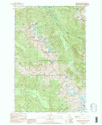
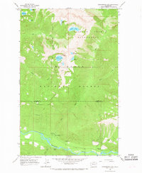
Glacier Peak Wilderness dominates this high-altitude landscape in the late 1980s, defined by its complex network of permanent ice and rugged drainage systems. The map illustrates the significant presence of active glaciers near the southern boundary, including the Milk Lake Glacier, Scimitar Glacier, Kennedy Glacier, and Ptarmigan Glacier, all clinging to the slopes surrounding Kennedy Peak. These ice fields feed glacial streams like Kennedy Creek and the headwaters of the White Chuck River.
Find a feature on this map
37 named features on this map. Tap any name to fly to it.
Don’t see what you’re looking for? This feature index may not catch every label — zoom into the map to look around manually.
Map Details
Editions of this 1988 Lime Mountain Map
2 editions found

Other maps of this area

1899 · Glacier Peak
USGS Topo · 1:125,000

1901 · Glacier Peak
USGS Topo · 1:125,000
1950 · Glacier Peak
USGS Topo · 1:62,500

1955 · Concrete
USGS Topo · 1:250,000

1958 · Concrete
USGS Topo · 1:250,000

1962 · Concrete
USGS Topo · 1:250,000
1963 · Downey Mtn
USGS Topo · 1:24,000
1963 · Dome Peak
USGS Topo · 1:24,000
1966 · Huckleberry Mtn
USGS Topo · 1:24,000
1966 · Sloan Peak
USGS Topo · 1:24,000