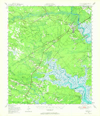
1948 Map of Limerick
USGS Topo · Published 1964About this map
The Canoochee River and Ogeechee River define the northern reaches of this coastal Georgia landscape, where tidal marshes and river networks shaped the region's development. In the southern sector, the historic settlement of Midway and the nearby Dorchester Academy stand as significant cultural landmarks amidst a terrain defined by Peacock Creek and the Medway River. The coastal economy of the late 1940s is visible in the operations at Sunbury, located near the Fort Morris (Abandoned) site, and the rail infrastructure of the Atlantic Coast Line and Seaboard Air Line railroads which connected these inland communities to larger markets. Educational and religious life is well-documented through numerous community hubs like the George Washington Carver School and Day Memorial Church, while the northern area features the U S Dept of Agriculture Plant Introduction Garden and a State Fish Hatchery.
Find a feature on this map
75 named features on this map. Tap any name to fly to it.
Don’t see what you’re looking for? This feature index may not catch every label — zoom into the map to look around manually.
Map Details
Editions of this 1948 Limerick Map
This is the sole edition of this map. No revisions or reprints were ever made.
Other maps of this area

1918 · Hinesville
USGS Topo · 1:62,500

1920 · Pembroke
USGS Topo · 1:62,500

1920 · Meldrim
USGS Topo · 1:62,500

1920 · Sapelo River
USGS Topo · 1:62,500

1920 · Limerick
USGS Topo · 1:62,500

1928 · St Catherines Island
USGS Topo · 1:62,500

1942 · Meldrim
USGS Topo · 1:62,500

1942 · Savannah
USGS Topo · 1:62,500

1943 · Ludowici
USGS Topo · 1:62,500

1943 · St Catherines Island
USGS Topo · 1:62,500