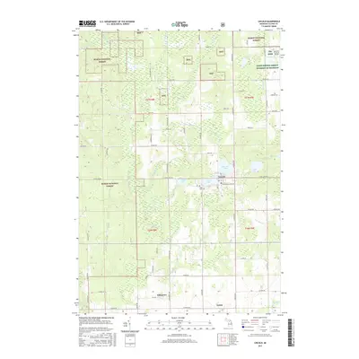
2017 Map of Lincoln
USGS Topo · Published 2017About this map
Lincoln serves as a focal point for this Alcona County landscape, situated near the shores of Brownlee Lake and Lincoln Lake. The surrounding terrain is defined by the extensive reaches of the Huron National Forest, where the headwaters and tributaries of the East Branch Pine River and Sucker Cr carve through the woodland. Further south, the settlement of Killmaster sits near the E Br Pine River, while Twin Lake Cem provides a point of genealogical interest for local researchers. The map captures a mix of public forest lands and agricultural interests, including the Farm Service Agency Interest of Michigan. Small aviation history is noted at the Milwrick Flying M Airport in the northeast, while numerous named roads like Sharbonneau Rd and N Barlow Rd establish the rural transport network.
Find a feature on this map
71 named features on this map. Tap any name to fly to it.
Don’t see what you’re looking for? This feature index may not catch every label — zoom into the map to look around manually.
Map Details
Editions of this 2017 Lincoln Map
This is the sole edition of this map. No revisions or reprints were ever made.
Other maps of this area

1954 · Tawas City
USGS Topo · 1:250,000

1958 · Tawas City
USGS Topo · 1:250,000

1959 · Glennie
USGS Topo · 1:62,500

1959 · Harrisville
USGS Topo · 1:62,500

1971 · Spruce
USGS Topo · 1:24,000
1971 · Black River
USGS Topo · 1:24,000

1972 · Hubbard Lake
USGS Topo · 1:24,000

1983 · Hubbard Lake
USGS Topo · 1:100,000
1989 · Harrisville
USGS Topo · 1:24,000
1989 · Barton City
USGS Topo · 1:24,000