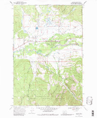
1968 Map of Lincoln
USGS Topo · Published 1980About this map
Lincoln serves as a central hub for the Upper Blackfoot Valley, surrounded by the extensive wilderness of the Helena National Forest. During the late 1960s, the landscape here reflects a combination of backcountry aviation at the Lincoln Airport and local recreation at the Hooper State Park and nearby Rodeo Ground. The valley floor is defined by the winding course of the Blackfoot River, supported by an intricate network of tributaries including Poorman Creek and Keep Cool Creek. High-elevation features like Baldy Mtn and the remote Liverpool Snowbank Trail (Pack) highlight the area's transition into the steeper terrain of the Continental Divide. Evidence of early resource management is found in the Grosfield Ditch and scattered operations such as the Lincoln Ranger Sta and several noted gravel pits and mines.
Find a feature on this map
34 named features on this map. Tap any name to fly to it.
Don’t see what you’re looking for? This feature index may not catch every label — zoom into the map to look around manually.
Map Details
Editions of this 1968 Lincoln Map
3 editions found
Other maps of this area

1889 · Helena
USGS Topo · 1:250,000

1893 · Helena
USGS Topo · 1:250,000

1899 · Helena
USGS Topo · 1:250,000

1903 · Coopers Lake
USGS Topo · 1:125,000

1903 · Helena
USGS Topo · 1:250,000

1947 · Butte
USGS Topo · 1:250,000

1955 · Choteau
USGS Topo · 1:250,000

1957 · Choteau
USGS Topo · 1:250,000

1958 · Butte
USGS Topo · 1:250,000

1958 · Choteau
USGS Topo · 1:250,000