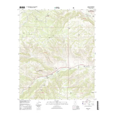
2017 Map of Lincoln
USGS Topo · Published 2017About this map
Lincoln and Glencoe anchor this study of the New Mexico landscape, situated within the Lincoln National Forest. The map documents a terrain defined by significant drainage systems, where the Rio Bonito flows through the northern reaches near the Lincoln Cem and the Rio Ruidoso cuts through the southern valley. This 2017 survey reveals a sophisticated network of named canyons and water sources essential to the region's ranching and settlement history, including Priest Canyon, Silva Canyon, and English Spring. The presence of several family-named landmarks like the Coe Cem and Glencoe Cem provides vital points of interest for those researching local lineage and burial sites. From the heights of Sierra Blanca to the Sacramento Mountains in the southeast, the map illustrates the complex topographical relationship between these high-elevation ranges and the critical water tanks and trails that support life in the valley.
Find a feature on this map
62 named features on this map. Tap any name to fly to it.
Don’t see what you’re looking for? This feature index may not catch every label — zoom into the map to look around manually.
Map Details
Editions of this 2017 Lincoln Map
This is the sole edition of this map. No revisions or reprints were ever made.
Other maps of this area

1934 · Capitan
USGS Topo · 1:48,000

1935 · Capitan Mountains
USGS Topo · 1:48,000

1937 · Capitan
USGS Topo · 1:62,500

1940 · Capitan Mountains
USGS Topo · 1:62,500

1955 · Roswell
USGS Topo · 1:250,000

1958 · Roswell
USGS Topo · 1:250,000

1961 · Lincoln
USGS Topo · 1:62,500

1962 · Roswell
USGS Topo · 1:250,000

1963 · Fort Stanton
USGS Topo · 1:24,000

1963 · Ruidoso Downs
USGS Topo · 1:24,000