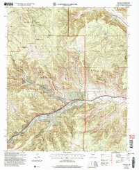
2004 Map of Lincoln
USGS Topo · Published 2006About this map
Lincoln stands as a focal point along Bonito Creek in this 2004 revision, which details the complex land management of the high desert and canyon country. The map illustrates a landscape partitioned between the Fort Stanton Recreation Area (BLM), the Lincoln National Forest, and the Military National Reservation Forest. This intersection of federal oversight highlights the area's importance for both recreation and historical military use. Along the Rio Ruidoso, the settlement of Glencoe is visible, accompanied by significant genealogical landmarks such as the St Annes Chapel and Glencoe Cem. Further west, the Sierra Blanca Regional Airport serves as a modern infrastructure anchor amidst the deep incisions of Devils Canyon and Cave Canyon. The presence of several family-named locations, including Buckhorn Ranch and the Coe Cem, provides a detailed view of the ranching legacy that has long defined this region of New Mexico.
Find a feature on this map
57 named features on this map. Tap any name to fly to it.
Don’t see what you’re looking for? This feature index may not catch every label — zoom into the map to look around manually.
Map Details
Editions of this 2004 Lincoln Map
This is the sole edition of this map. No revisions or reprints were ever made.
Other maps of this area

1934 · Capitan
USGS Topo · 1:48,000

1935 · Capitan Mountains
USGS Topo · 1:48,000

1937 · Capitan
USGS Topo · 1:62,500

1940 · Capitan Mountains
USGS Topo · 1:62,500

1955 · Roswell
USGS Topo · 1:250,000

1958 · Roswell
USGS Topo · 1:250,000

1961 · Lincoln
USGS Topo · 1:62,500

1962 · Roswell
USGS Topo · 1:250,000

1963 · Fort Stanton
USGS Topo · 1:24,000

1963 · Ruidoso Downs
USGS Topo · 1:24,000