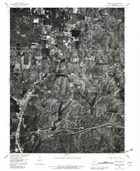
1980 Map of Lincoln SE
USGS Topo · Published 1982About this map
The Osage River winds through the southern portion of this 1980 orthophotograph, serving as the core of a landscape defined by significant water management projects. This aerial survey captures the confluence of two major regional water bodies: the expansive Lake of the Ozarks and the southern reaches of the Harry S Truman Reservoir. The contrast between the wooded, dissected hillsides along the river valley and the more regular agricultural field patterns to the north is clearly visible through the 1:80,000-scale photography. A small settlement node at Poplar anchors the central portion of the quadrangle, illustrating the dispersed rural habitation typical of this part of Missouri during the early 1980s. The map provides a precise record of shoreline development and land use just as these reservoirs became established features of the regional geography.
Find a feature on this map
4 named features on this map. Tap any name to fly to it.
Don’t see what you’re looking for? This feature index may not catch every label — zoom into the map to look around manually.
Map Details
Editions of this 1980 Lincoln SE Map
This is the sole edition of this map. No revisions or reprints were ever made.
Other maps of this area

1887 · Warsaw
USGS Topo · 1:125,000

1894 · Warsaw
USGS Topo · 1:125,000

1935 · Edwards
USGS Topo · 1:24,000

1935 · Dell
USGS Topo · 1:24,000

1936 · Shawnee Bend
USGS Topo · 1:24,000

1936 · Lakeview Heights
USGS Topo · 1:24,000

1936 · Schuyler
USGS Topo · 1:24,000

1945 · Fristoe
USGS Topo · 1:62,500

1947 · Jefferson City
USGS Topo · 1:250,000

1954 · Jefferson City
USGS Topo · 1:250,000