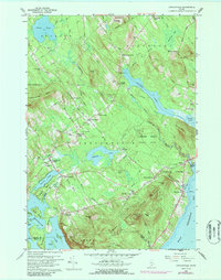
1960 Map of Lincolnville
USGS Topo · Published 1987About this map
Lincolnville and its surrounding coastal hills are defined by a network of inland ponds and a short stretch of Penobscot Bay frontage. The landscape transitions from the elevations of Megunticook Mtn and Bald Rock Mtn down toward the Ducktrap River valley. This 1960 record, with revisions through the early 1970s, illustrates a settled countryside marked by family-named crossroads like Clarks Corner, Drake Corner, and Grange Corner. The presence of numerous small burying grounds, including the Collier Cem and Beach Cem, speaks to the deep-rooted genealogical history of Waldo County.
Find a feature on this map
85 named features on this map. Tap any name to fly to it.
Don’t see what you’re looking for? This feature index may not catch every label — zoom into the map to look around manually.
Map Details
Editions of this 1960 Lincolnville Map
3 editions found
Other maps of this area

1902 · Castine
USGS Topo · 1:62,500

1904 · Castine
USGS Topo · 1:62,500

1904 · Vinalhaven
USGS Topo · 1:62,500

1904 · Rockland
USGS Topo · 1:62,500

1905 · Penobscot Bay
USGS Topo · 1:125,000

1906 · Rockland
USGS Topo · 1:62,500

1915 · Belfast
USGS Topo · 1:62,500

1917 · Belfast
USGS Topo · 1:62,500

1941 · Belfast
USGS Topo · 1:62,500

1941 · Rockland
USGS Topo · 1:62,500