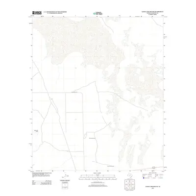
2012 Map of Linda Lake South
USGS Topo · Published 2012About this map
Old Meeks Windmill and Cottonwood Windmill stand as vital landmarks in this arid stretch of West Texas, highlighting the importance of water infrastructure for local ranching operations. The terrain is characterized by broad drainage patterns such as Eightmile Draw, which cuts through the desert floor. In this sparsely populated landscape, water features like Russel Tank provide critical focal points for navigation and land use. The presence of Ranch Road 1576 suggests the primary transportation corridor connecting these isolated points across the salt flat and desert scrub environment, where infrastructure remains centered around the needs of large-scale cattle ranching and property management.
Find a feature on this map
5 named features on this map. Tap any name to fly to it.
Don’t see what you’re looking for? This feature index may not catch every label — zoom into the map to look around manually.
Map Details
Editions of this 2012 Linda Lake South Map
This is the sole edition of this map. No revisions or reprints were ever made.
Other maps of this area

1933 · Guadalupe Peak
USGS Topo · 1:48,000

1940 · Guadalupe Peak
USGS Topo · 1:62,500

1951 · Dell City
USGS Topo · 1:62,500

1954 · Van Horn
USGS Topo · 1:250,000

1955 · Black Mountains
USGS Topo · 1:62,500

1958 · Van Horn
USGS Topo · 1:250,000

1973 · Bitter Well Mountain NW
USGS Topo · 1:24,000
1973 · Patterson Hills
USGS Topo · 1:24,000
1973 · P X Flat
USGS Topo · 1:24,000
1984 · Dell City
USGS Topo · 1:24,000