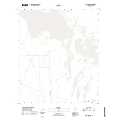
2019 Map of Linda Lake South
USGS Topo · Published 2019About this map
Linda Lake and the expansive Salt Basin dominate this high-desert landscape in Hudspeth County. This modern survey illustrates the sparse, arid character of the region, where water management is critical to ranching operations. Significant water features such as Russel Tank indicate localized efforts to collect and store runoff in an environment otherwise defined by ephemeral drainage patterns like Eightmile Draw. The map shows a landscape largely shaped by its topography and the few reliable transit corridors, primarily Ranch Rd 1576, which serves as the primary artery through this remote section of the Trans-Pecos. The presence of large salt flats and basins suggests a geologic history of internal drainage and evaporation, characteristic of the basin and range province.
Find a feature on this map
5 named features on this map. Tap any name to fly to it.
Don’t see what you’re looking for? This feature index may not catch every label — zoom into the map to look around manually.
Map Details
Editions of this 2019 Linda Lake South Map
This is the sole edition of this map. No revisions or reprints were ever made.
Other maps of this area

1933 · Guadalupe Peak
USGS Topo · 1:48,000

1940 · Guadalupe Peak
USGS Topo · 1:62,500

1951 · Dell City
USGS Topo · 1:62,500

1954 · Van Horn
USGS Topo · 1:250,000

1955 · Black Mountains
USGS Topo · 1:62,500

1958 · Van Horn
USGS Topo · 1:250,000

1973 · Bitter Well Mountain NW
USGS Topo · 1:24,000
1973 · Patterson Hills
USGS Topo · 1:24,000
1973 · P X Flat
USGS Topo · 1:24,000
1984 · Dell City
USGS Topo · 1:24,000