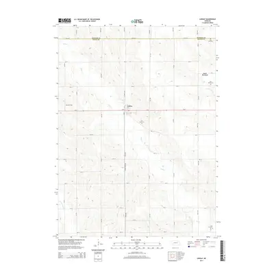
2014 Map of Lindsay
USGS Topo · Published 2014About this map
Lindsay sits at the intersection of Ne-91 and the Lindsay-Genoa Rd, serving as a central hub for the surrounding agricultural landscape of Platte County. The map documents a significant religious and community presence through several burial grounds, including Holy Family Cem near the town center and Saint Bernard Cem to the northeast. The terrain is defined by the winding paths of Shell Creek and its tributaries, which carve through the grid of section roads and farm plots. Along the northern boundary, the Madison Co Platte Co line separates these rural communities. To the south, Looking Glass Creek meanders through the landscape, while small local landmarks like Johnston Field provide insight into the township's spatial organization during the early twenty-first century.
Find a feature on this map
27 named features on this map. Tap any name to fly to it.
Don’t see what you’re looking for? This feature index may not catch every label — zoom into the map to look around manually.
Map Details
Editions of this 2014 Lindsay Map
This is the sole edition of this map. No revisions or reprints were ever made.
Other maps of this area

1955 · Fremont
USGS Topo · 1:250,000

1957 · Fremont
USGS Topo · 1:250,000

1958 · Fremont
USGS Topo · 1:250,000

1958 · St. Edward
USGS Topo · 1:24,000

1963 · Closter SE
USGS Topo · 1:24,000

1963 · Battle Creek SE
USGS Topo · 1:24,000

1963 · Battle Creek SW
USGS Topo · 1:24,000
1966 · Newman Grove
USGS Topo · 1:24,000

1966 · Tarnov
USGS Topo · 1:24,000
1966 · Lindsay SW
USGS Topo · 1:24,000