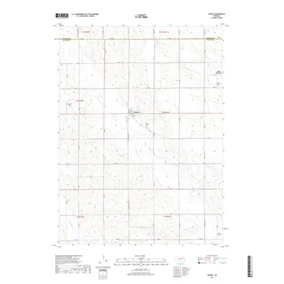
2017 Map of Lindsay
USGS Topo · Published 2017About this map
Lindsay and the nearby community of Saint Bernard anchor this agricultural landscape along the northern edge of Platte County. The terrain is defined by the winding paths of Shell Cr and S Fork Union Cr, which carve through the sectional grid of the Nebraska plains. For genealogists and local historians, the map provides precise locations for several regional burial grounds, including the Holy Family Cem just south of Lindsay and the Saint Bernard Cem to the east. The northern border follows Co Line Rd, marking the boundary with Madison County. Aviation history is noted by the inclusion of Johnston Field, while the rural infrastructure is detailed through an extensive network of secondary roads such as Lindsay-Genoa Rd and McPhillips Rd.
Find a feature on this map
35 named features on this map. Tap any name to fly to it.
Don’t see what you’re looking for? This feature index may not catch every label — zoom into the map to look around manually.
Map Details
Editions of this 2017 Lindsay Map
This is the sole edition of this map. No revisions or reprints were ever made.
Other maps of this area

1955 · Fremont
USGS Topo · 1:250,000

1957 · Fremont
USGS Topo · 1:250,000

1958 · Fremont
USGS Topo · 1:250,000

1958 · St. Edward
USGS Topo · 1:24,000

1963 · Closter SE
USGS Topo · 1:24,000

1963 · Battle Creek SE
USGS Topo · 1:24,000

1963 · Battle Creek SW
USGS Topo · 1:24,000
1966 · Newman Grove
USGS Topo · 1:24,000

1966 · Tarnov
USGS Topo · 1:24,000
1966 · Lindsay SW
USGS Topo · 1:24,000