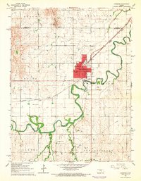
1965 Map of Lindsborg
USGS Topo · Published 1966About this map
Bethany College stands as a central landmark in this mid-century survey of the Little Sweden area, where the Union Pacific and Missouri Pacific railroads converge. The topography is defined by the winding course of the Smoky Hill River, which cuts through the landscape near the prominent Smoky Hill Buttes and Coronado Heights Park. This era captures a balance of education, industry, and agriculture, from the concentrated town grid of Lindsborg to the southern Lindsborg South Oil Field.
Find a feature on this map
33 named features on this map. Tap any name to fly to it.
Don’t see what you’re looking for? This feature index may not catch every label — zoom into the map to look around manually.
Map Details
Editions of this 1965 Lindsborg Map
3 editions found
Other maps of this area

1891 · Hutchinson
USGS Topo · 1:125,000

1892 · Salina
USGS Topo · 1:125,000

1893 · Hutchinson
USGS Topo · 1:125,000

1942 · Salina
USGS Topo · 1:125,000

1955 · Assaria
USGS Topo · 1:24,000

1955 · Smolan
USGS Topo · 1:24,000

1955 · Falun
USGS Topo · 1:24,000

1955 · Hutchinson
USGS Topo · 1:250,000

1959 · Hutchinson
USGS Topo · 1:250,000

1964 · Marquette
USGS Topo · 1:24,000