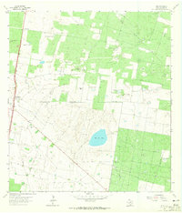
1963 Map of Linn
USGS Topo · Published 1965About this map
The salt lake Sal del Rey anchors this portion of Hidalgo County, a land defined by deep-rooted ranching traditions and the mid-century expansion of the energy sector. By the early 1960s, the landscape was a grid of family-named ranch holdings and extensive gas exploration, evidenced by the San Manuel Gas Field and Sal del Rey Gas Field. The settlement at Linn serves as a small hub along U.S. Route 281, while the nearby San Manuel community sits amidst a terrain dotted with numerous wind-powered wells like the San Juan Windmill and El Toro Windmill. Genealogy researchers will find significant value in the documentation of established estates such as San Felipe Ranch, El Rucio Ranch, and Tres Corrales Ranch, alongside the El Rucio Cem, which preserves the history of the families who settled this brush country long before the modern pipelines arrived.
Find a feature on this map
31 named features on this map. Tap any name to fly to it.
Don’t see what you’re looking for? This feature index may not catch every label — zoom into the map to look around manually.
Map Details
Editions of this 1963 Linn Map
2 editions found
Other maps of this area

1922 · La Sal Vieja
USGS Topo · 1:62,500

1939 · Linn
USGS Topo · 1:62,500

1949 · Mc Allen
USGS Topo · 1:250,000

1953 · Brownsville
USGS Topo · 1:250,000

1954 · McAllen
USGS Topo · 1:250,000

1956 · Andrea Ranch
USGS Topo · 1:24,000

1956 · La Sal Vieja
USGS Topo · 1:24,000

1956 · La Sal Vieja
USGS Topo · 1:62,500

1956 · Brownsville
USGS Topo · 1:250,000

1956 · Port Isabel
USGS Topo · 1:250,000