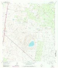
1963 Map of Linn
USGS Topo · Published 1984About this map
The salt lake Sal del Rey anchors this landscape in the Rio Grande Valley, surrounded by the extensive San Manuel Gas Field and Sal Del Rey Gas Field. The settlement of Linn serves as a small rail and road hub along route 281, marked by its Grain Elevator and nearby San Manuel. The map reveals a deeply rooted ranching heritage, with family-named properties like El Rucio Ranch, Rancho del Carmine, and La Nopalosa Ranch dotting the brushland. Genealogists will find particular value in the El Rucio Cem, located north of the primary settlements. The presence of numerous named windmills, such as the Aguaje Windmill and La Esperanza Windmill, illustrates the vital infrastructure required for cattle operations in the Los Machos Pasture. This 1963 survey, updated with 1980s data, documents the intersection of South Texas petroleum extraction and traditional ranching.
Find a feature on this map
33 named features on this map. Tap any name to fly to it.
Don’t see what you’re looking for? This feature index may not catch every label — zoom into the map to look around manually.
Map Details
Editions of this 1963 Linn Map
2 editions found
Other maps of this area

1922 · La Sal Vieja
USGS Topo · 1:62,500

1939 · Linn
USGS Topo · 1:62,500

1949 · Mc Allen
USGS Topo · 1:250,000

1953 · Brownsville
USGS Topo · 1:250,000

1954 · McAllen
USGS Topo · 1:250,000

1956 · Andrea Ranch
USGS Topo · 1:24,000

1956 · La Sal Vieja
USGS Topo · 1:24,000

1956 · La Sal Vieja
USGS Topo · 1:62,500

1956 · Brownsville
USGS Topo · 1:250,000

1956 · Port Isabel
USGS Topo · 1:250,000