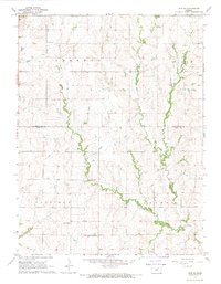
1968 Map of Linn SE
USGS Topo · Published 1969About this map
The rolling agricultural landscape of north-central Kansas is defined by the winding paths of Fancy Creek and its tributaries, West Fancy Creek and Carter Creek, which cut through the townships of Sherman, Goshen, and Garfield. This late 1960s survey documents a rural society structured around its township lines and local landmarks, featuring small social hubs like Fact and a Townhall near the southern boundary. Local education and faith are represented by St Johns Sch, while family histories are anchored by the Center Mission Cem and Central Cem. The map provides a precise record of the upland prairie's drainage patterns and the network of section roads that connect these isolated farmsteads and civic centers across the Washington and Clay County line.
Find a feature on this map
23 named features on this map. Tap any name to fly to it.
Don’t see what you’re looking for? This feature index may not catch every label — zoom into the map to look around manually.
Map Details
Editions of this 1968 Linn SE Map
This is the sole edition of this map. No revisions or reprints were ever made.
Other maps of this area

1886 · Junction City
USGS Topo · 1:125,000

1889 · Marysville
USGS Topo · 1:125,000

1889 · Junction City
USGS Topo · 1:125,000

1891 · Clay Center
USGS Topo · 1:125,000

1893 · Washington
USGS Topo · 1:125,000

1894 · Junction City
USGS Topo · 1:125,000

1894 · Marysville
USGS Topo · 1:125,000

1955 · Manhattan
USGS Topo · 1:250,000

1956 · Manhattan
USGS Topo · 1:250,000

1957 · Manhattan
USGS Topo · 1:250,000