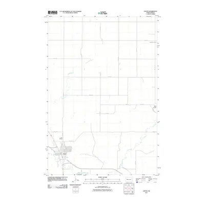
2011 Map of Linton
USGS Topo · Published 2011About this map
Linton serves as the primary center of activity in this Emmons County landscape, situated where several local waterways converge. The town's grid is detailed with residential streets such as E Oak Ave, E Walnut Ave, and W Schley Ave, illustrating the community's organization in the early 21st century. The surrounding terrain is defined by the winding paths of Spring Creek, Clear Creek, and Beaver Creek, which shape the rural acreage outside the town limits. Local history and genealogy are anchored by Saint Anthonys Cemetery on the western edge of the settlement and Bethlehem Cemetery to the northeast. The presence of the Spring Water Lake Dam on the eastern side of the quadrangle indicates local water management efforts in this prairie region, while a sparse network of section-line roads like 11th Ave SE and 73rd St SE connects the outlying farmsteads.
Find a feature on this map
42 named features on this map. Tap any name to fly to it.
Don’t see what you’re looking for? This feature index may not catch every label — zoom into the map to look around manually.
Map Details
Editions of this 2011 Linton Map
This is the sole edition of this map. No revisions or reprints were ever made.
Other maps of this area

1954 · Bismarck
USGS Topo · 1:250,000

1958 · Bismarck
USGS Topo · 1:250,000

1971 · Hazelton
USGS Topo · 1:24,000

1971 · Grassna NE
USGS Topo · 1:24,000

1971 · Strasburg
USGS Topo · 1:24,000

1971 · Temvik
USGS Topo · 1:24,000

1975 · Appert Lake
USGS Topo · 1:24,000

1975 · Linton NE
USGS Topo · 1:24,000

1979 · Senger Lake North
USGS Topo · 1:24,000
1980 · Linton
USGS Topo · 1:24,000