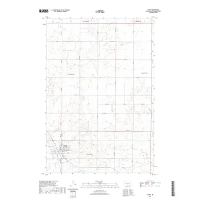
2017 Map of Linton
USGS Topo · Published 2017About this map
Linton serves as the primary hub of this Emmons County landscape, positioned near the confluence of several vital watercourses. The town's grid extends toward Beaver Creek and is bounded by streets like W Sampson Ave and S Milwaukee Ave. The surrounding rural sections are defined by a network of sectional roads and the meandering paths of Spring Cr and Clear Cr. Local genealogy and land history are anchored by several dedicated burial grounds, including Bethlehem Cem on the northeastern edge and Saint Anthonys Cem closer to the town center. Further south, Raynolds' Cem marks a distinct point of interest along the creek banks. The map documents the persistent agricultural and residential structure of this North Dakota region, from the family-named Bosch Ln to the expansive township boundaries like t132n r76w.
Find a feature on this map
31 named features on this map. Tap any name to fly to it.
Don’t see what you’re looking for? This feature index may not catch every label — zoom into the map to look around manually.
Map Details
Editions of this 2017 Linton Map
This is the sole edition of this map. No revisions or reprints were ever made.
Other maps of this area

1954 · Bismarck
USGS Topo · 1:250,000

1958 · Bismarck
USGS Topo · 1:250,000

1971 · Hazelton
USGS Topo · 1:24,000

1971 · Grassna NE
USGS Topo · 1:24,000

1971 · Strasburg
USGS Topo · 1:24,000

1971 · Temvik
USGS Topo · 1:24,000

1975 · Appert Lake
USGS Topo · 1:24,000

1975 · Linton NE
USGS Topo · 1:24,000

1979 · Senger Lake North
USGS Topo · 1:24,000
1980 · Linton
USGS Topo · 1:24,000