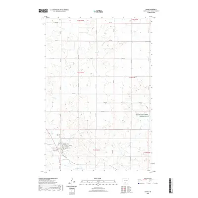
2020 Map of Linton
USGS Topo · Published 2020About this map
Linton serves as the primary hub in this portion of Emmons County, situated near the confluence of Spring Cr and Beaver Creek. The town's grid is clearly defined by streets such as Broadway St N and S Milwaukee Ave, reflecting its development as a regional center. To the east, the landscape transitions into the protected wetlands and prairies of the Springwater National Wildlife Refuge, which dominates the southeastern quadrant of the survey. The mapping provides significant detail for researchers, showing the placement of rural landmarks like Bethlehem Cem in the northeast and Saint Anthonys Cem just north of the main settlement. The drainage patterns of Clear Cr and Beaver Cr illustrate the hydrological network that has shaped the agricultural layout of the Missouri Plateau region.
Find a feature on this map
46 named features on this map. Tap any name to fly to it.
Don’t see what you’re looking for? This feature index may not catch every label — zoom into the map to look around manually.
Map Details
Editions of this 2020 Linton Map
This is the sole edition of this map. No revisions or reprints were ever made.
Other maps of this area

1954 · Bismarck
USGS Topo · 1:250,000

1958 · Bismarck
USGS Topo · 1:250,000

1971 · Hazelton
USGS Topo · 1:24,000

1971 · Grassna NE
USGS Topo · 1:24,000

1971 · Strasburg
USGS Topo · 1:24,000

1971 · Temvik
USGS Topo · 1:24,000

1975 · Appert Lake
USGS Topo · 1:24,000

1975 · Linton NE
USGS Topo · 1:24,000

1979 · Senger Lake North
USGS Topo · 1:24,000
1980 · Linton
USGS Topo · 1:24,000