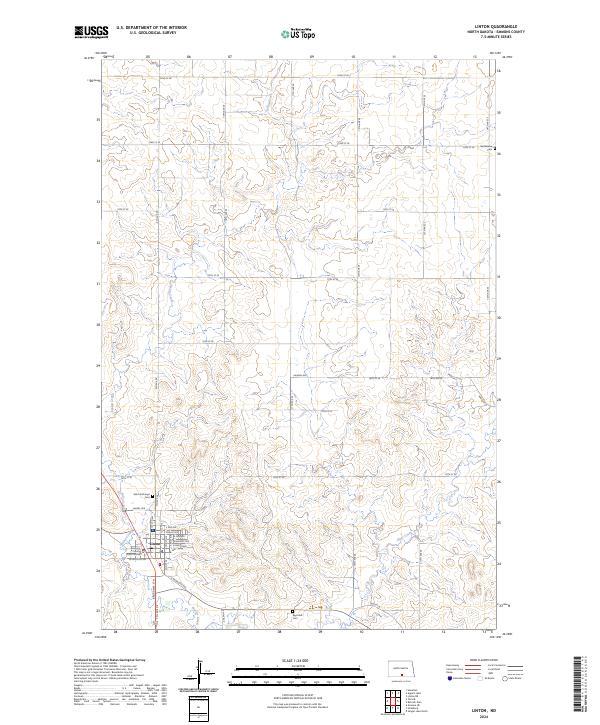
2024 Map of Linton
USGS Topo · Published 2024About this map
Linton serves as the focal point of this North Dakota landscape, situated at the confluence of several vital watercourses including Spring Creek and Beaver Creek. The town's significance as a local government center is marked by the Emmons County Court House, while its community history is preserved at sites like Saint Anthonys Cem and Raynolds Cem. To the east, the Springwater National Wildlife Refuge indicates the conservation priorities of the modern era, protecting the wetlands and prairie potholes characteristic of the region. The map reveals a structured grid of agricultural roads, such as 72nd St SE and 13th Ave SE, which define the section lines of the Northern Plains. This network connects the isolated Bethlehem Cem in the northeast to the residential streets of the town center, including Broadway St N and E Elm Ave.
Find a feature on this map
43 named features on this map. Tap any name to fly to it.
Don’t see what you’re looking for? This feature index may not catch every label — zoom into the map to look around manually.
Map Details
Editions of this 2024 Linton Map
This is the sole edition of this map. No revisions or reprints were ever made.
Other maps of this area

1954 · Bismarck
USGS Topo · 1:250,000

1958 · Bismarck
USGS Topo · 1:250,000

1971 · Hazelton
USGS Topo · 1:24,000

1971 · Grassna NE
USGS Topo · 1:24,000

1971 · Strasburg
USGS Topo · 1:24,000

1971 · Temvik
USGS Topo · 1:24,000

1975 · Appert Lake
USGS Topo · 1:24,000

1975 · Linton NE
USGS Topo · 1:24,000

1979 · Senger Lake North
USGS Topo · 1:24,000
1980 · Linton
USGS Topo · 1:24,000