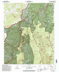
1994 Map of Linville Falls
USGS Topo · Published 1998About this map
Linville Falls and the surrounding high country of the Blue Ridge define this landscape at the intersection of Avery, Burke, McDowell, and Mitchell counties. This 1994 revision captures a complex network of geological landmarks and early mountain settlements before modern expansion, where the Blue Ridge Parkway winds through the Pisgah National Forest. The geography is anchored by the deep incision of the Linville Gorge, while subterranean features like Linville Caverns and surface landmarks such as Table Rock Mountain and The Chimneys reflect the area's long-standing status as a destination for exploration. Local genealogy is rooted in the small congregations and family plots scattered across the ridges, including Walnut Grove Church, Concord Church, and Wise Cemetery. Traces of earlier industry remain visible in labels like the Strip Mine on Pink Ridge, contrasting with the protected expanse of the Linville Gorge Wilderness.
Find a feature on this map
51 named features on this map. Tap any name to fly to it.
Don’t see what you’re looking for? This feature index may not catch every label — zoom into the map to look around manually.
Map Details
Editions of this 1994 Linville Falls Map
2 editions found
Other maps of this area

1891 · Roan Mountain
USGS Topo · 1:125,000

1893 · Cranberry
USGS Topo · 1:125,000

1894 · Roan Mountain
USGS Topo · 1:125,000

1895 · Cranberry
USGS Topo · 1:125,000

1899 · Cranberry
USGS Topo · 1:125,000

1900 · Mount Mitchell
USGS Topo · 1:125,000

1902 · Cranberry
USGS Topo · 1:125,000

1902 · Mount Mitchell
USGS Topo · 1:125,000

1904 · Roan Mountain
USGS Topo · 1:125,000

1905 · Morganton
USGS Topo · 1:125,000