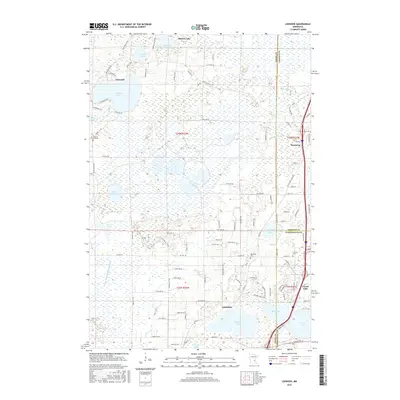
2016 Map of Linwood
USGS Topo · Published 2016About this map
The lowlands and lake districts at the junction of Anoka, Chisago, and Washington Counties are defined by an intricate network of waterways and glacial depressions. Linwood Lake and the smaller Island Lake anchor the northwestern portion of this area, where the settlement of Linwood sits near the headwaters of County Ditch Number Forty-one. The landscape is a mosaic of wetlands and rising ground, evidenced by the numerous lakes including Martin Lake, Boot Lake, and Clear Lake. To the southeast, the growing hubs of Columbus and Forest Lake show the intersection of local routes like Co Hwy 18 and Viking Blvd NE. Local history is anchored by several burial sites, such as Victor Hill Cem near the western edge and Oak Park Cem situated north of Howard Lake, which serve as permanent markers of the area's rural development and multi-county ties.
Find a feature on this map
105 named features on this map. Tap any name to fly to it.
Don’t see what you’re looking for? This feature index may not catch every label — zoom into the map to look around manually.
Map Details
Editions of this 2016 Linwood Map
This is the sole edition of this map. No revisions or reprints were ever made.
Other maps of this area

1902 · White Bear
USGS Topo · 1:62,500

1948 · Stillwater
USGS Topo · 1:62,500

1949 · Stillwater
USGS Topo · 1:62,500

1952 · Centerville
USGS Topo · 1:24,000

1953 · Stillwater
USGS Topo · 1:250,000

1954 · Hugo
USGS Topo · 1:24,000

1955 · Circle Pines
USGS Topo · 1:24,000

1955 · Forest Lake
USGS Topo · 1:62,500

1955 · Isanti
USGS Topo · 1:62,500
1955 · New Brighton
USGS Topo · 1:62,500