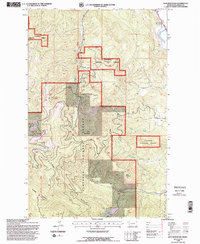
1994 Map of Lion Mountain
USGS Topo · Published 1996About this map
Flathead National Forest encompasses the high country of the Salish Mountains in this mid-1990s topographic record. The landscape is defined by prominent peaks like Lion Mountain, Baldy Mountain, and Blacktail Mountain, which overlook a network of drainages including Stoner Creek, Bierney Creek, and Cramer Creek. The geography here reflects a managed wilderness, where the Flathead Guide Meridian cuts through deep valleys and timbered slopes. Evidence of land use is found in labels for a Gravel Pit and an Electronic Site, while the Old Grade in the northeast corner hints at earlier transportation routes through the mountainous terrain. Small bodies of water like Lost Lake are tucked into the high elevations, while larger tributaries like Birch Creek and Patrick Creek navigate the complex topography of the Flathead region.
Find a feature on this map
15 named features on this map. Tap any name to fly to it.
Don’t see what you’re looking for? This feature index may not catch every label — zoom into the map to look around manually.
Map Details
Editions of this 1994 Lion Mountain Map
2 editions found
Other maps of this area

1920 · Flathead Lake
USGS Topo · 1:125,000

1943 · Kalispell
USGS Topo · 1:125,000

1956 · Wallace
USGS Topo · 1:250,000

1957 · Kalispell
USGS Topo · 1:250,000

1960 · Kalispell
USGS Topo · 1:250,000

1960 · Wallace
USGS Topo · 1:250,000

1961 · Kalispell
USGS Topo · 1:250,000

1962 · Kila
USGS Topo · 1:24,000

1962 · Blue Grass Ridge
USGS Topo · 1:24,000

1962 · Lion Mountain
USGS Topo · 1:24,000