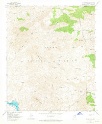
1964 Map of Lion Mountain
USGS Topo · Published 1965About this map
Tonto National Forest spans this mid-1960s survey of the high desert and mountain country where Yavapai and Maricopa counties meet. The landscape is defined by the steep drainages of the Mazatzal Mountains, with high points like Lion Mountain and Sheep Mountain overlooking a network of springs and canyons. In the southern reach, the Verde River feeds into the Bartlett Reservoir, where underwater contours provided by the Salt River Project reveal the submerged topography near the spillway.
Find a feature on this map
45 named features on this map. Tap any name to fly to it.
Don’t see what you’re looking for? This feature index may not catch every label — zoom into the map to look around manually.
Map Details
Editions of this 1964 Lion Mountain Map
3 editions found
Other maps of this area

1887 · Verde
USGS Topo · 1:250,000

1892 · Verde
USGS Topo · 1:250,000

1907 · Roosevelt
USGS Topo · 1:125,000

1909 · Four Peaks
USGS Topo · 1:125,000

1912 · Roosevelt
USGS Topo · 1:125,000

1929 · Turret Peak
USGS Topo · 1:125,000

1930 · Cave Creek
USGS Topo · 1:125,000

1933 · Turret Peak
USGS Topo · 1:125,000

1936 · Payson
USGS Topo · 1:48,000

1939 · Cave Creek
USGS Topo · 1:125,000