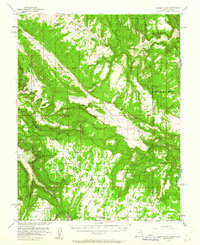
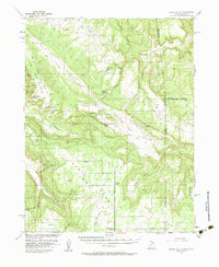
1954 Map of Lisbon Valley
USGS Topo · Published 1961About this map
Lisbon Valley sits at the heart of this mid-century landscape, straddling the high desert borderlands where San Juan County meets the Colorado state line. Surveyed in cooperation with the Atomic Energy Commission, the map reveals an era of active exploration, marked by various prospect sites, a Shaft, and Tunnels that point to the region's uranium mining boom. Isolated agricultural outposts like Woods Ranch and Patterson Ranch are tucked into the drainages of Big Indian Wash and Bullhorn Wash, while the West Summit School serves the sparse population near Summit Point. The terrain is defined by dramatic mesas and notches, most notably Middle Mesa and the prominent Lisbon Gap. These landforms created natural corridors for movement, which were later utilized for the limited roads and unimproved dirt tracks that connect the valley to the more established settlements in the surrounding high plateau country.
Find a feature on this map
45 named features on this map. Tap any name to fly to it.
Don’t see what you’re looking for? This feature index may not catch every label — zoom into the map to look around manually.
Map Details
Editions of this 1954 Lisbon Valley Map
5 editions found
Other maps of this area

1885 · La Sal
USGS Topo · 1:250,000

1886 · Abajo
USGS Topo · 1:250,000

1892 · Abajo
USGS Topo · 1:250,000

1893 · Abajo
USGS Topo · 1:250,000

1916 · Paradox Valley
USGS Topo · 1:125,000

1922 · Paradox Valley
USGS Topo · 1:125,000

1948 · Horse Range Mesa
USGS Topo · 1:24,000

1948 · Paradox
USGS Topo · 1:24,000

1949 · Paradox
USGS Topo · 1:24,000

1949 · Egnar
USGS Topo · 1:24,000