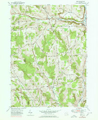
1949 Map of Lisle
USGS Topo · Published 1980About this map
Lisle sits at the confluence of Dudley Creek and the Tioughnioga River, anchoring a landscape defined by sharp ridges and deep creek valleys in northern Broome County. This mid-century survey captures the region's historical transport corridor along the Catskill Turnpike, which follows the Dudley Creek valley through Center Lisle and Manningville. The eastern edge of the quadrangle is marked by the industrial presence of the Delaware Lackawanna and Western RR, which runs parallel to the river. Further south, the terrain transitions into the drainage basins of Nanticoke Creek and its tributaries, including the Ketchumville Branch. Small upland settlements like Ketchumville and Glen Aubrey remain connected by a network of rural roads such as Telman Road and Davis Hollow Road, reflecting a distributed agricultural and timber-reliant economy typical of the Southern Tier during this era.
Find a feature on this map
41 named features on this map. Tap any name to fly to it.
Don’t see what you’re looking for? This feature index may not catch every label — zoom into the map to look around manually.
Map Details
Editions of this 1949 Lisle Map
2 editions found
Other maps of this area

1901 · Apalachin
USGS Topo · 1:62,500

1903 · Harford
USGS Topo · 1:62,500

1904 · Binghamton
USGS Topo · 1:62,500

1904 · Greene
USGS Topo · 1:62,500

1904 · Apalachin
USGS Topo · 1:62,500

1906 · Catatonk
USGS Topo · 1:125,000

1934 · Castle Creek
USGS Topo · 1:24,000

1942 · Castle Creek
USGS Topo · 1:31,680

1948 · Binghamton
USGS Topo · 1:250,000
1949 · Whitney Point
USGS Topo · 1:24,000