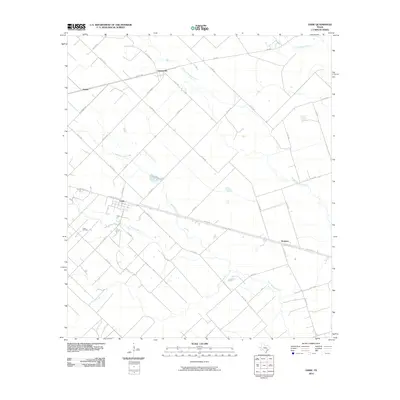
2010 Map of Lissie
USGS Topo · Published 2010About this map
Lissie and its surrounding agricultural prairie are defined by a grid of rural roads and the drainage of the San Bernard River system. This area of Wharton County reflects a landscape long-dominated by ranching and rice farming, bisected by the prominent corridor of US Hwy 90 Alt. The settlement of Lissie sits at a geographic hub for several county roads, while smaller locales like Nottawa and Chesterville anchor the outlying sections. Evidence of the region's energy resources is found southwest of the primary townsite at the Lissie Oil Field. The natural topography is characterized by a network of seasonal watercourses, including West Bernard Creek, Dewberry Branch, and Gum Tree Branch, which wind through the rectilinear property lines and drainage canals that shape this part of the Texas coastal plain.
Find a feature on this map
41 named features on this map. Tap any name to fly to it.
Don’t see what you’re looking for? This feature index may not catch every label — zoom into the map to look around manually.
Map Details
Editions of this 2010 Lissie Map
This is the sole edition of this map. No revisions or reprints were ever made.
Other maps of this area

1952 · Egypt
USGS Topo · 1:24,000

1953 · Hungerford
USGS Topo · 1:24,000

1953 · Seguin
USGS Topo · 1:250,000

1956 · Wallis
USGS Topo · 1:62,500

1957 · Eagle Lake
USGS Topo · 1:62,500

1958 · Seguin
USGS Topo · 1:250,000

1959 · Bonus
USGS Topo · 1:24,000

1960 · Lissie
USGS Topo · 1:24,000

1960 · Wallis
USGS Topo · 1:24,000
1960 · East Bernard
USGS Topo · 1:24,000