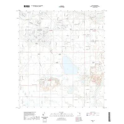
2021 Map of Lithia
USGS Topo · Published 2021About this map
The Alafia River and its numerous tributaries, including the N Prong Alafia River and S Prong Alafia River, dominate this modern Florida landscape where suburban expansion meets traditional hammocks. Residential developments such as Fish Hawk contrast with the natural surroundings of Coleman Hammock and Stallion Hammock. Water is the defining characteristic of the region, from the recreational draw of Lithia Springs to the southern wetlands surrounding Hurrah Lake and Hurrah Bay. Local history and infrastructure are represented by the Lithia Cem and the Stanchester Airport near Pinecrest. The presence of several named hammocks, including Chapman Hammock and Cabbage Hammock, suggests the persistence of these elevated hardwood islands amidst the low-lying drainage basins of Long Flat Creek and Doe Branch.
Find a feature on this map
128 named features on this map. Tap any name to fly to it.
Don’t see what you’re looking for? This feature index may not catch every label — zoom into the map to look around manually.
Map Details
Editions of this 2021 Lithia Map
This is the sole edition of this map. No revisions or reprints were ever made.
Other maps of this area

1921 · Tampa
USGS Topo · 1:62,500

1944 · Mango
USGS Topo · 1:31,680

1944 · Wimauma
USGS Topo · 1:31,680

1944 · Balm
USGS Topo · 1:31,680

1947 · Wimauma
USGS Topo · 1:25,000

1955 · Lithia
USGS Topo · 1:24,000

1955 · Nichols
USGS Topo · 1:24,000

1955 · Dover
USGS Topo · 1:24,000

1955 · Keysville
USGS Topo · 1:24,000
1956 · Riverview
USGS Topo · 1:24,000