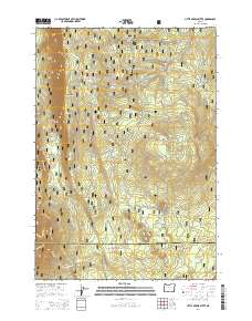
2014 Map of Little Akawa Butte
USGS Topo · Published 2014About this map
Green Ridge dominates the western half of this landscape within the Cascade Range on the border of Deschutes and Jefferson counties. This 2014 survey captures a terrain defined by dramatic elevation changes, where high volcanic plateaus drop sharply into the Akawa Gulch and the distinctive topographic break known as The Gap. The map documents a complex network of forest roads and trails, such as the B-1 Logging Road and the Allingham Cutoff, which trace the historical and modern timber economy of the Deschutes National Forest. Water sources are vital landmarks in this high-altitude environment, including Bear Spring located near the northern boundary. The detailed contour lines reveal the volcanic geology of the region, from the slopes of Garrison Butte to the prominence of Little Akawa Butte, providing a clear record of the area's natural drainage and ridgelines.
Find a feature on this map
5 named features on this map. Tap any name to fly to it.
Don’t see what you’re looking for? This feature index may not catch every label — zoom into the map to look around manually.
Map Details
Editions of this 2014 Little Akawa Butte Map
This is the sole edition of this map. No revisions or reprints were ever made.
Other maps of this area

1926 · Bend
USGS Topo · 1:125,000

1927 · Mt. Jefferson
USGS Topo · 1:125,000

1928 · Madras
USGS Topo · 1:125,000

1929 · Bend
USGS Topo · 1:125,000

1929 · Three Sisters
USGS Topo · 1:125,000

1930 · Mt. Jefferson
USGS Topo · 1:125,000

1931 · Madras
USGS Topo · 1:125,000

1932 · Three Sisters
USGS Topo · 1:125,000

1955 · Bend
USGS Topo · 1:250,000

1957 · Bend
USGS Topo · 1:250,000