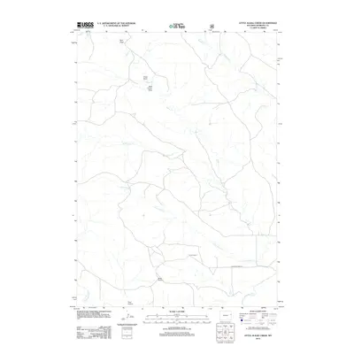
2012 Map of Little Alkali Creek
USGS Topo · Published 2012About this map
Carlas Corner serves as a lone reference point in this corner of Niobrara County, where the high plains landscape is defined by a network of seasonal drainages and draws. The southern portion of the map is dominated by the course of the Cheyenne River, which is paralleled by Cheyenne River Rd. To the north, the terrain rises toward named landmarks such as Bridle Bit Hill and a series of distinctively named gullies including Bum Draw, Trout Draw, and Rock Corral Draw. This area’s hydrology is characterized by the branching systems of Alkali Creek and Little Alkali Creek, which snake through the territory toward their eventual confluence. The nomenclature here, including the striking Fatal Hollow, speaks to the challenges of ranching and navigation in the eastern Wyoming backcountry, reflecting a geographic isolation that persisted into the early 21st century.
Find a feature on this map
12 named features on this map. Tap any name to fly to it.
Don’t see what you’re looking for? This feature index may not catch every label — zoom into the map to look around manually.
Map Details
Editions of this 2012 Little Alkali Creek Map
This is the sole edition of this map. No revisions or reprints were ever made.
Other maps of this area

1899 · Newcastle
USGS Topo · 1:125,000

1901 · Newcastle
USGS Topo · 1:125,000

1951 · Dewey SW
USGS Topo · 1:24,000

1955 · Newcastle
USGS Topo · 1:250,000

1958 · Newcastle
USGS Topo · 1:250,000

1978 · Riverview
USGS Topo · 1:24,000

1978 · Mule Creek
USGS Topo · 1:24,000

1979 · Newcastle
USGS Topo · 1:100,000

1981 · Threemile Butte
USGS Topo · 1:24,000
1981 · Little Alkali Creek
USGS Topo · 1:24,000