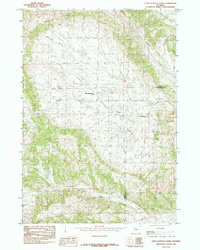
1985 Map of Little Buffalo Basin
USGS Topo · Published 1985About this map
The Little Buffalo Basin is defined by a significant energy extraction landscape, where an extensive Oil Field and an associated Landing Strip illustrate the industrial development of Park and Hot Springs counties. This 1985 edition, based on field checks from 1979, captures the infrastructure of the Little Buffalo Basin Camp amid the drainage systems of Gooseberry Creek and Little Buffalo Creek. The terrain is marked by distinctive local landmarks such as the Hole in the Ground in the northeast and Middle Cr to the south. The map provides a clear look at the intersection of resource industry and the natural watershed, recording the placement of wells and access roads during a peak era of regional production.
Find a feature on this map
10 named features on this map. Tap any name to fly to it.
Don’t see what you’re looking for? This feature index may not catch every label — zoom into the map to look around manually.
Map Details
Editions of this 1985 Little Buffalo Basin Map
This is the sole edition of this map. No revisions or reprints were ever made.
Other maps of this area

1911 · Meeteetse
USGS Topo · 1:62,500

1913 · Meeteetse
USGS Topo · 1:62,500

1913 · Grass Creek Basin
USGS Topo · 1:62,500

1915 · Grass Creek Basin
USGS Topo · 1:62,500

1951 · Hillberry Rim
USGS Topo · 1:24,000

1951 · Wilson Spring
USGS Topo · 1:24,000

1955 · Cody
USGS Topo · 1:250,000

1955 · Thermopolis
USGS Topo · 1:250,000

1956 · Soapy Dale Peak
USGS Topo · 1:24,000

1956 · Adam Weiss Peak
USGS Topo · 1:24,000