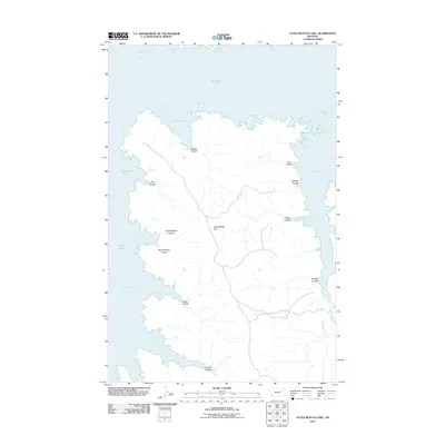
2011 Map of Little Buffalo Hill
USGS Topo · Published 2011About this map
Little Buffalo Hill stands as a prominent landmark in this segment of Valley County, where the sprawling waters of Fort Peck Lake define the western and northern landscape. The shoreline is characterized by a series of deeply indented inlets and bays, such as Hell Creek Bay, Bebee Coulee Bay, and Crooked Creek Bay, each formed by the flooding of traditional drainage systems. These coulees, including North Whitey Coulee and South Whitey Coulee, illustrate the intricate erosion patterns of the Missouri River breaks. While the terrain is dominated by these water-filled canyons and ridgelines, the map also traces more subtle drainage features like Kibler Coulee and Johnson Coulee that feed into the larger system. This modern survey reflects the contemporary extent of the reservoir, a critical feature for regional water management and recreation in Montana, while documenting the exact nomenclature of the local landforms.
Find a feature on this map
16 named features on this map. Tap any name to fly to it.
Don’t see what you’re looking for? This feature index may not catch every label — zoom into the map to look around manually.
Map Details
Editions of this 2011 Little Buffalo Hill Map
This is the sole edition of this map. No revisions or reprints were ever made.
Other maps of this area

1954 · Jordan
USGS Topo · 1:250,000

1956 · Jordan
USGS Topo · 1:250,000

1958 · Jordan
USGS Topo · 1:250,000

1958 · Collins Ranch
USGS Topo · 1:62,500

1958 · Maloney Hill
USGS Topo · 1:62,500
1958 · Seventh Point Buttes
USGS Topo · 1:24,000

1964 · Jordan
USGS Topo · 1:250,000
1972 · Kester School
USGS Topo · 1:24,000
1972 · Signal Butte
USGS Topo · 1:24,000

1978 · Fort Peck Lake East
USGS Topo · 1:100,000