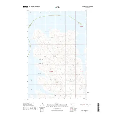
2020 Map of Little Buffalo Hill
USGS Topo · Published 2020About this map
Fort Peck Lake dominates the northern reaches of this landscape, where the waters of the reservoir reach into the deeply eroded drainage systems of the Missouri River breaks. The terrain is characterized by a dense network of coulees, including Beebe Coulee and Kibler Coulee, which carve through the high ground toward the lake's many inlets like Beebe Coulee Bay and Hell Creek Bay. The boundary between Valley and Garfield counties winds across the water and through the western draws, marking a transition in this remote part of Montana. At the center of the sheet, Little Buffalo Hill serves as a primary landmark among the complex ridges. This survey illustrates the intricate shoreline and dramatic relief of the breaks, showing how the land was shaped both by the natural drainage of features like Rough Coulee and the massive scale of the twentieth-century dam project that flooded these valleys.
Find a feature on this map
21 named features on this map. Tap any name to fly to it.
Don’t see what you’re looking for? This feature index may not catch every label — zoom into the map to look around manually.
Map Details
Editions of this 2020 Little Buffalo Hill Map
This is the sole edition of this map. No revisions or reprints were ever made.
Other maps of this area

1954 · Jordan
USGS Topo · 1:250,000

1956 · Jordan
USGS Topo · 1:250,000

1958 · Jordan
USGS Topo · 1:250,000

1958 · Collins Ranch
USGS Topo · 1:62,500

1958 · Maloney Hill
USGS Topo · 1:62,500
1958 · Seventh Point Buttes
USGS Topo · 1:24,000

1964 · Jordan
USGS Topo · 1:250,000
1972 · Kester School
USGS Topo · 1:24,000
1972 · Signal Butte
USGS Topo · 1:24,000

1978 · Fort Peck Lake East
USGS Topo · 1:100,000