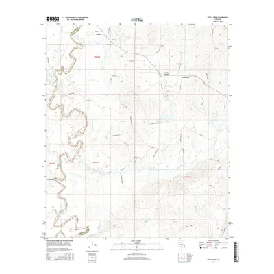
2015 Map of Little Creek
USGS Topo · Published 2015About this map
Zenoria and Hester anchor the northern landscape of this Central Louisiana survey, where the Little River carves a winding path along the boundary of Grant Parish and LaSalle Parish. The region is defined by a complex network of waterways, including the meandering Lincecum Bayou and Bayou Funny Louis, which flow through the low-lying basins. Local history is preserved at several rural burial grounds such as Chalk Hill Cem near the settlement of Little Creek and Pine Bluff Cem further south. The presence of Oil FLD labels and numerous local roads like Chalk Hill Cemetery Rd and Lincecum Bayou Rd reflect the area's dual character of petroleum extraction and small-scale timberland settlement. From the heights of Doughty Bluff to the bend of Woodward Lake, the map provides a precise look at the drainage patterns and land divisions of the early 21st century.
Find a feature on this map
69 named features on this map. Tap any name to fly to it.
Don’t see what you’re looking for? This feature index may not catch every label — zoom into the map to look around manually.
Map Details
Editions of this 2015 Little Creek Map
This is the sole edition of this map. No revisions or reprints were ever made.
Other maps of this area

1936 · Pollock
USGS Topo · 1:62,500

1941 · Jena
USGS Topo · 1:62,500

1941 · Pollock
USGS Topo · 1:62,500

1953 · Alexandria
USGS Topo · 1:250,000

1954 · Tullos
USGS Topo · 1:62,500

1955 · Alexandria
USGS Topo · 1:250,000

1955 · Olla
USGS Topo · 1:62,500

1958 · Pollock
USGS Topo · 1:62,500

1958 · Jena
USGS Topo · 1:62,500
1984 · Summerville
USGS Topo · 1:24,000