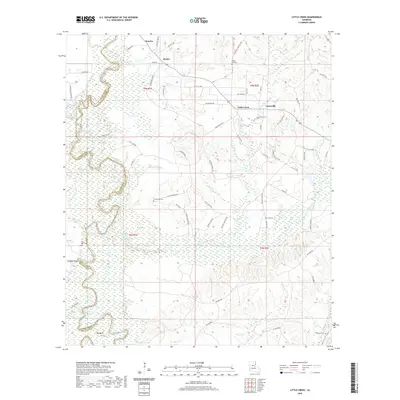
2020 Map of Little Creek
USGS Topo · Published 2020About this map
Little River defines the western edge of this central Louisiana landscape, marking the winding border between Grant Parish and LaSalle Parish. In the north, the community of Little Creek and nearby Ganeyville sit atop higher ground, while the southern reaches descend into a complex network of wetlands and seasonal water bodies. The land here is deeply shaped by timber and energy extraction, visible through a dense grid of Oil-Field Rd and Tram Rd segments that crisscross the terrain near Bayou Funny Louis. Local history is anchored by several rural burying grounds, including Chalk Hill Cem and Hawthorne Cem, which serve as lasting markers of early settlement. From the heights of Doughty Bluff down to the low-lying Big Bend, the map reveals a traditional Southern riverine economy transitioning between forest management and petroleum production.
Find a feature on this map
78 named features on this map. Tap any name to fly to it.
Don’t see what you’re looking for? This feature index may not catch every label — zoom into the map to look around manually.
Map Details
Editions of this 2020 Little Creek Map
This is the sole edition of this map. No revisions or reprints were ever made.
Other maps of this area

1936 · Pollock
USGS Topo · 1:62,500

1941 · Jena
USGS Topo · 1:62,500

1941 · Pollock
USGS Topo · 1:62,500

1953 · Alexandria
USGS Topo · 1:250,000

1954 · Tullos
USGS Topo · 1:62,500

1955 · Alexandria
USGS Topo · 1:250,000

1955 · Olla
USGS Topo · 1:62,500

1958 · Pollock
USGS Topo · 1:62,500

1958 · Jena
USGS Topo · 1:62,500
1984 · Summerville
USGS Topo · 1:24,000