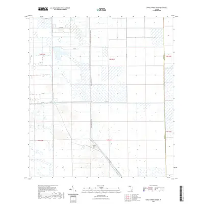
2021 Map of Little Cypress Swamp
USGS Topo · Published 2021About this map
Little Cypress Swamp dominates this landscape along the border of Hendry and Palm Beach counties, where the transition into the northern reaches of The Everglades is marked by a sophisticated network of drainage and agricultural infrastructure. The territory is defined by a grid of citrus groves and agricultural tracts like Tcp Farms, supported by water management features such as the Deer Fence Canal. This 2021 survey reveals how modern land use persists in this wetland environment, with the Florida National Scenic Trl cutting a long north-south path through the center of the quadrangle. Human activity is concentrated along rural corridors like Co Rd 835 and Blumberg Rd, while the Southern Ranch Airport serves as a remote aviation outpost for the surrounding ranching and farming operations.
Find a feature on this map
18 named features on this map. Tap any name to fly to it.
Don’t see what you’re looking for? This feature index may not catch every label — zoom into the map to look around manually.
Map Details
Editions of this 2021 Little Cypress Swamp Map
This is the sole edition of this map. No revisions or reprints were ever made.
Other maps of this area

1956 · West Palm Beach
USGS Topo · 1:250,000

1957 · West Palm Beach
USGS Topo · 1:250,000

1958 · West Palm Beach
USGS Topo · 1:250,000

1970 · Lake Harbor SE
USGS Topo · 1:24,000

1970 · Lake Harbor SW
USGS Topo · 1:24,000

1970 · La Belle 4 SE
USGS Topo · 1:24,000

1974 · Everglades 2 SW
USGS Topo · 1:24,000

1974 · Immokalee 1 SE
USGS Topo · 1:24,000

1974 · Immokalee 1 NE
USGS Topo · 1:24,000

1974 · Everglades 2 SE
USGS Topo · 1:24,000