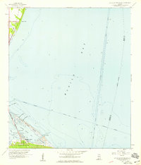
1958 Map of Little Dauphin Island
USGS Topo · Published 1959About this map
Dauphin Island serves as the focal point of this coastal survey, where the established settlement meets the complex waterways of Mobile Bay. The landscape is defined by its maritime infrastructure, featuring the Dauphin Island Bridge (Toll) connecting Mon Louis Island to the mainland, and the intersecting paths of the Mobile Ship Channel and the Intracoastal Waterway. Local history is preserved at Indian Mound Park and a small Cem, reflecting both the natural and cultural heritage of the Gulf Coast.
Find a feature on this map
29 named features on this map. Tap any name to fly to it.
Don’t see what you’re looking for? This feature index may not catch every label — zoom into the map to look around manually.
Map Details
Editions of this 1958 Little Dauphin Island Map
3 editions found
Other maps of this area

1921 · Point Clear
USGS Topo · 1:62,500

1921 · Dauphin Island
USGS Topo · 1:62,500

1921 · Delchamps
USGS Topo · 1:62,500

1941 · Cedar Point
USGS Topo · 1:62,500

1941 · Weeks Bay
USGS Topo · 1:62,500

1942 · Fort Morgan
USGS Topo · 1:62,500

1943 · Cedar Point
USGS Topo · 1:62,500

1943 · Weeks Bay
USGS Topo · 1:62,500

1953 · Mobile
USGS Topo · 1:250,000
1956 · Point Clear
USGS Topo · 1:24,000