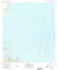
1958 Map of Little Dauphin Island
USGS Topo · Published 1983About this map
Dauphin Island and the adjacent waters of Mobile Bay define this mid-century maritime landscape. The map illustrates a pivotal era for the barrier island as it transitioned toward a permanent residential and recreational community, anchored by the construction of the Dauphin Island Bridge connecting from Mon Louis Island. While Alabama Port sits to the north, the island itself shows concentrated development along Bienville Blvd, including a municipal Landing Strip and Indian Mound Park.
Find a feature on this map
31 named features on this map. Tap any name to fly to it.
Don’t see what you’re looking for? This feature index may not catch every label — zoom into the map to look around manually.
Map Details
Editions of this 1958 Little Dauphin Island Map
3 editions found
Other maps of this area

1921 · Point Clear
USGS Topo · 1:62,500

1921 · Dauphin Island
USGS Topo · 1:62,500

1921 · Delchamps
USGS Topo · 1:62,500

1941 · Cedar Point
USGS Topo · 1:62,500

1941 · Weeks Bay
USGS Topo · 1:62,500

1942 · Fort Morgan
USGS Topo · 1:62,500

1943 · Cedar Point
USGS Topo · 1:62,500

1943 · Weeks Bay
USGS Topo · 1:62,500

1953 · Mobile
USGS Topo · 1:250,000
1956 · Point Clear
USGS Topo · 1:24,000