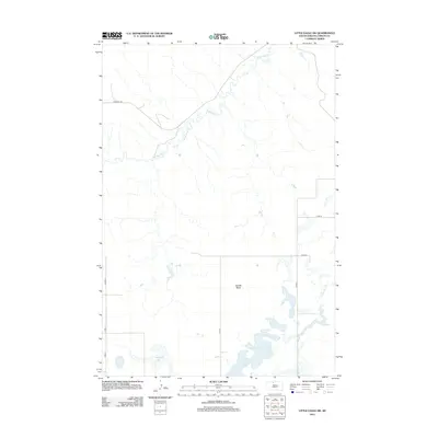
2012 Map of Little Eagle SW
USGS Topo · Published 2012About this map
Saddle Butte rises above the open prairie of Corson County in this early 21st-century study of the Standing Rock Indian Reservation landscape. The drainage patterns of the northern plains are clearly defined by the winding course of High Bank Cr and Little Oak Cr, which cut through the high ground in the northern and eastern portions of the quadrangle. In the southern reach, the terrain softens into a series of wetlands and small basins including Spring Lake and Dogeagle Lake. Human imprint on the land is represented primarily by a sparse network of section-line roads and named routes like Firesteel Rd, reflecting the remote ranching and agricultural character of this region of South Dakota.
Find a feature on this map
11 named features on this map. Tap any name to fly to it.
Don’t see what you’re looking for? This feature index may not catch every label — zoom into the map to look around manually.
Map Details
Editions of this 2012 Little Eagle SW Map
This is the sole edition of this map. No revisions or reprints were ever made.
Other maps of this area

1953 · McIntosh
USGS Topo · 1:250,000

1956 · Little Eagle SW
USGS Topo · 1:24,000

1956 · Little Eagle
USGS Topo · 1:24,000

1956 · Little Eagle SE
USGS Topo · 1:24,000

1956 · Miscol SE
USGS Topo · 1:24,000

1956 · Little Eagle NW
USGS Topo · 1:24,000

1956 · Miscol NE
USGS Topo · 1:24,000

1958 · McIntosh
USGS Topo · 1:250,000

1975 · Glencross
USGS Topo · 1:24,000
1975 · Glencross NE
USGS Topo · 1:24,000