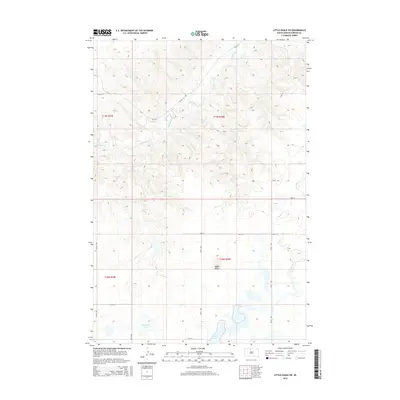
2015 Map of Little Eagle SW
USGS Topo · Published 2015About this map
Saddle Butte rises as a prominent local landmark above the open rangeland of Corson County, shaping the drainage patterns for the surrounding prairie. This 2015 survey of the Standing Rock Reservation area reveals a landscape defined by seasonal watercourses like High Bank Cr and Little Oak Cr, which cut through the high ground in the northern reaches. The southern portion of the quadrangle is characterized by a flatter, more depressed basin that holds Spring Lake and Dogeagle Lake, indicating the varied hydrologic nature of this plains environment. A sparse but systematic road network, including Bia Rd 4 and various township avenues like 259th Ave, serves the isolated tracts of land, reflecting the modern logistical structure of the region's agricultural and tribal lands.
Find a feature on this map
18 named features on this map. Tap any name to fly to it.
Don’t see what you’re looking for? This feature index may not catch every label — zoom into the map to look around manually.
Map Details
Editions of this 2015 Little Eagle SW Map
This is the sole edition of this map. No revisions or reprints were ever made.
Other maps of this area

1953 · McIntosh
USGS Topo · 1:250,000

1956 · Little Eagle SW
USGS Topo · 1:24,000

1956 · Little Eagle
USGS Topo · 1:24,000

1956 · Little Eagle SE
USGS Topo · 1:24,000

1956 · Miscol SE
USGS Topo · 1:24,000

1956 · Little Eagle NW
USGS Topo · 1:24,000

1956 · Miscol NE
USGS Topo · 1:24,000

1958 · McIntosh
USGS Topo · 1:250,000

1975 · Glencross
USGS Topo · 1:24,000
1975 · Glencross NE
USGS Topo · 1:24,000