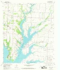
1960 Map of Little Elm
USGS Topo · Published 1969About this map
Garza - Little Elm Reservoir dominates this 1960s landscape, its sprawling fingers reaching into the surrounding Texas plains. The settlement of Little Elm sits at the water's edge, surrounded by rural communities like Navo and New Hope. The map reflects a transition from traditional farming land to a recreational and water-management hub, documented by the presence of Frisco Park, Camp Dallas, and Camp Lucille along the western shorelines.
Find a feature on this map
27 named features on this map. Tap any name to fly to it.
Don’t see what you’re looking for? This feature index may not catch every label — zoom into the map to look around manually.
Map Details
Editions of this 1960 Little Elm Map
2 editions found
Other maps of this area

1925 · Mc Kinney 3-c
USGS Topo · 1:48,000

1929 · Frisco
USGS Topo · 1:62,500

1954 · Sherman
USGS Topo · 1:250,000

1958 · Sherman
USGS Topo · 1:250,000

1960 · Frisco
USGS Topo · 1:24,000

1960 · Green Valley
USGS Topo · 1:24,000

1960 · Celina
USGS Topo · 1:24,000

1960 · Aubrey
USGS Topo · 1:24,000
1960 · Lewisville East
USGS Topo · 1:24,000
1960 · Hebron
USGS Topo · 1:24,000